Search
You Searched For
Search Results
- Published / Created:
- 1777
- Call Number:
- 774hc M88 1777A
- Container / Volume:
- BRBL_00714
- Image Count:
- 1
- Resource Type:
- Maps, Atlases & Globes
- Found in:
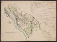
- Beinecke Rare Book and Manuscript Library > A Plan of Mud Island and Fort Mifflin with the Siege thereof, and its Evacuation the 15th of November 1777. Also Red Bank with the Shoals Banks Islands & Flats in the Extent. Drawn by Charles Blaskowitz, Captain of Guides & Pioneers.
- Published / Created:
- 1778
- Call Number:
- 774hc B274 1778
- Container / Volume:
- BRBL_00714
- Image Count:
- 1
- Resource Type:
- Maps, Atlases & Globes
- Found in:
- Beinecke Rare Book and Manuscript Library > Plan de la Retraite de Barrenhill en Pensilvanie on un detachement de deux mile deux cent hommes, sour le Gral. la Fayette etoit entourre par l'armee Angloise sour les Gaux Howe, Clinton, et Grant, le 28 May, 1778.
- Published / Created:
- [1813]
- Call Number:
- 774 M193 1813
- Container / Volume:
- BRBL_00714
- Image Count:
- 4
- Resource Type:
- Maps, Atlases & Globes
- Found in:
- Beinecke Rare Book and Manuscript Library > [Manuscript map of McKean County].